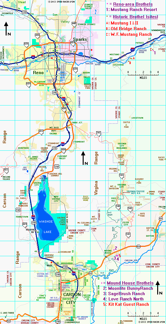
Western NV
Carson City-area (Mound House) Brothels:
Western NV
Carson City-area (Mound House) Brothels:(Kit Kat, Love Ranch North, Moonlite BunnyRanch, and SageBrush)
Western NV
Carson City-area (Mound House) Brothels:
Across the street the extensive interior rebuilding of the Kit Kat, which has been closed for around a year now, continues. It now appears that the Kit Kat name may be retained by Mr. Hof, though no official announcement as to that has been made. According to the October 2013 edition of Hof's online BunnyRanch Newsletter, those renovations are nearing completion, but no formal reopening date for the house has yet been set or announced. Stay tuned for further developments!
The former surface route of highway 395 – from Virginia St near Tahoe Junction (exit 57) and along the Carson-Reno Highway south through Pleasant Valley and Washoe City to Winters Ranch – which had been officially listed as a part of Nevada S.R. 430, has been resigned by NDOT as Alternate U.S. 395 (US 395A). That new 395A designation also extends further south to include the pre-1970, historical routing of highway 395 through Franktown in Washoe Valley along Bowers Mansion Road (most recently Nevada S.R. 429) all the way back to the freeway at the Eastlake Boulevard interchange (exit 44). During high wind events, truck and high-profile vehicle traffic may be diverted to use 395A as necessary. See the Reno-Carson City area map below.
Remaining work on I-580 includes the final phase of the Carson City Freeway (from Fairview Dr south and west to the Spooner Junction interchange site on S. Carson St (U.S. 395 SOUTH) at U.S. 50 WEST), which is yet to be scheduled due to funding issues (though certain preliminary work has already begun). The 1.78-mile open section between William St and Fairview Dr is not yet officially I-580, but is co-signed as U.S. 50 and U.S. 395, which use Fairview and Carson as a temporary connection for route continuity.
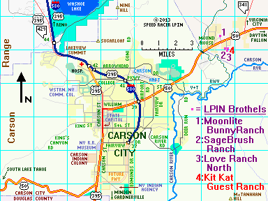 How to get to the Carson City area Brothels:
Detailed Maps of:
Mound House
Reno to Carson City region
CLICK HERE for information on major Western Nevada Road Construction Projects
Return to the top
Return to the Western Nevada index
Return to directions index
Dennis Hof's Kit Kat Ranch - Currently CLOSED & possibly to soon be renamed
51 Kit Kat Drive
Mound House, NV 89706-7453
Website:
www.bunnyranch.com - Note: site of common message board for all of Dennis Hof's brothels - check there for current status info on this house
Phone Numbers:
none at present
GPS Information:
Coordinates: 39° 12' 33.35"N -- 119° 39' 47.95"W
Elevation: 4815'
Prior Historical Names and Abbreviations:
KKGR: The Kit Kat Guest Ranch
KKR: The Kit Kat Ranch
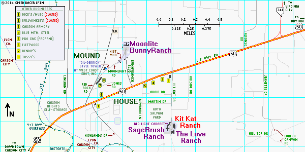
The brothel that gave its name to the street, the Kit Kat is found on the left (east) side after you drive the four blocks south from U.S. 50. It shares kind of a "cul-de-sac"-type parking area with its neighboring bordellos (none of which shared any common ownership interests prior to October 2012). The Kit Kat's most recent previous owners, Shelia and Jacie Caramella, sold the house to Dennis Hof, owner of the neighboring Love Ranch North and nearby Moonlite BunnyRanch in early October 2012. The brothel closed for business after October 28, 2012, and a large sign presently directs patrons to visit the Love Ranch next door until "renovations" can be completed.
The Kit Kat is an older house and had a cramped parlor and tiny rooms for the ladies with shared bathrooms in bewteen them. While the Caramellas had made some renovations during their tenure, Hof elected to gut the house and completely rebuild its interior. Also, the outdoor pool and its surrounding deck area have experienced major problems due to shifting ground beneath it, causing numerous water leaks. Long-range plans by Mr. Hof remain unclear, but it is anticipated that due to the proximity of his Love Ranch North next door on Kit Kat Drive there may be plans afoot to either link those two houses or build some shared amenities (such as a new pool) in between them if/when the steeply sloping ground there can be stabilized. Time will tell. Furthermore, it was thought that the Kit Kat would get a completely new name once it reopens; however, it appears that Hof may have changed his mind on that possibility. Especially given the facts that, (A) it matches the name of the street on which it and now two of his other houses sit, and (B) the country may be averse to changing that road's name to match any potential change in moniker of this particular house.
Dennis Hof's Love Ranch North
Also known as: Dennis Hof's Love Ranch Cathouse or The Love Ranch Northern NV
95 Kit Kat Drive
Mound House, NV 89706
Websites:
www.loveranch.net - Note: common site for both Love Ranch North & Love Ranch Vegas
www.bunnyranch.com - Note: site of common message board for all of Dennis Hof's brothels
Phone Numbers:
(775) 246-7077 local
GPS Information:
Coordinates: 39° 12' 31.55"N -- 119° 39' 48.05"W
Elevation: 4813'
Prior Historical Names and Abbreviations:
TLR: The Love Ranch (2008-2012)
BR2: BunnyRanch Two (2004-2008)
MKC: Miss Kitty's Cathouse (2002-2004)
KPL: Kitty's Pussycat Lounge (1998-2002)
MKFR: Madame Kitty's Fantasy Ranch (until 1998)
The Love Ranch North (LRN) can be found at the southeast end of the Kit Kat Drive "LPIN cul-de-sac" off U.S. 50 in Mound House - just past the other two, formerly unaffiliated brothels on that street. It is about a mile from owner Dennis Hof's original bordello in this part of the state, his flagship Moonlite BunnyRanch (MLBR). With Hof's more recent acquisition of the neighboring Kit Kat (October 2012) and SageBrush (July 2013), he now has a monopoly on the legal brothel business in Lyon County, and his three brothels and one gentlemens club on Kit Kat Drive are being actively marketed as Mound House's "Red Light District".
History
Formerly known under several variations of the "Kitty's" moniker (which was carried over from the name of its original owner, as well as the fictional "Miss Kitty" from the popular former TV show Gunsmoke), as of late February 2004 present owner Dennis Hof changed it's name to BunnyRanch Two (BR2) to bear the same "family name" as his best-known brothel, the nearby MLBR. However, this often caused confusion since the houses shared a single website and didn't at that time distinguish which particular ladies worked where. All too often, the MLBR was also incorrectly referred to by many as the "BR1". This caused more problems, as the ladies of BR2 disliked being thought of as somehow being "#2" when compared to their sister working ladies at the nearby Moonlite. So on June 16, 2008, Hof again changed the name of this house, this time to "The Love Ranch" (TLR). For a time, the ladies who work there were then called "CowgirlCuties" to better distinguish them from their "BunnyBabe" sisters over at the MLBR, but this nickname quickly fell out of favor, eventually replaced by the current "Love Ranch Lover" designation. Upon Hof's August 2010 acquisition of a brothel in southern Nevada (Nye County) which was eventually given a similar name, this western Nevada house began being referred to as the Love Ranch North (LRN), though neither house's official legal name contains any cardinal direction at present.
During the BR2 era, the former jacuzzi room was completely remodeled into a luxurious VIP suite (don't fret - the jacuzzi remains) and the old Kitty's parlor decor and funrnishings were upgraded. But whatever their name, and however nice their remodeled facilities were, the ladies still remained the main attraction, as always!
Before early 2004, this brothel was known as "Miss Kitty's Cathouse", a name it was given in late 2002. Prior to that time, it was known as "Ms. Kitty's Pussycat Lounge"; while before 1998, it was known as "Madam Kitty's Fantasy Ranch". Because Mr. Hof had put so much time, money, and effort into promoting the original BunnyRanch, many claimed he was "ignoring" his other local establishment. So, to make the ladies and staff there feel more a part of (in his words) "Team BunnyRanch", to capitalize on the name recognition he has built up for the brand name, and as a possible precursor to expansion of his brothel domain internationally, officially became the "BunnyRanch Two". But as stated above, that name only lasted for a bit over four years, and now this venerable old house has been rechristened as The Love Ranch, or since Hof's 2011 expansion into Nye County, the Love Ranch North.
Dennis Hof's World Famous Moonlite BunnyRanch
69 Moonlight Road
Mound House, NV 89706
Website:
www.bunnyranch.com
Phone Numbers:
(888) BUN-NYRA toll-free
(775) 246-9901 local
GPS Information:
Coordinates: 39° 13' 06.95"N -- 119° 40' 14.7"W
Elevation: 4983'
Prior Historical Names and Abbreviations:
MLR: The Moonlite Ranch - name used after purchase by Dennis Hof
MLR: The Moonlight Ranch - original name used from 1955 until Dennis Hof became owner
Billed as "world famous", no doubt due to owner Dennis Hof's never-ending quest for publicity, the Moonlite BunnyRanch (a/k/a the BunnyRanch or the MLBR) sits alone on the north side of U.S. 50 relative to the three other brothels here in Mound House, which as of July 2013 are also under Hof's ownership.
By the way, the Moonlite BunnyRanch (officially, no space between the last two words) is usually abbreviated as MLBR, rather than MBR, to avoid any possible confusion with the long-closed Mustang Bridge Ranch up in northwestern Storey County (which was one of the original names used by the Mustang Ranch prior to the legalization of prostitution in Nevada). Also, prior to Dennis Hof's ownership, The Moonlite BunnyRanch was known as the Moonlight Ranch (same spelling as the street it is officially addressed on). In 2000, Mr. Hof changed the MLBR's mailing address from 30 to 69 (for obvious reasons), since he owns all of the property that far up Moonlight Rd.
History - Recent
A new access road directly from U.S. Highway 50 to the parking lot of the Moonlite BunnyRanch (MLBR) was opened on February 18, 2009. BunnyRanch Boulevard is located approximately midway between U.S. 50's intersection with Red Rock Rd (where you used to have to turn to get to the MLBR) and that highway's subsequent intersection with Kit Kat Dr, the road leading to Dennis Hof's other three local brothels. Follow this boulevard up the hill (through an old, recalimed strip mine) and past the now-infamous yellow diamond "humping bunny crossing" warning sign (which you road geeks won't find depicted in the Standard Highway Signs book of the Manual on Uniform Traffic Control Devices) to the MLBR parking lot.
In 2003, the BunnyRanch was featured in two major specials, entitled Cathouse, on the HBO television service. In 2005, a multi-part sequel Cathouse: The Series premiered on that same network and occassional new episodes are still produced today. Don't fret however, you are in no danger of being filmed without your permission if you choose to visit this establishment and desire anonymity.
Alternate & Historical Entrance (U.S. 50 to Red Rock Rd to Moonlight Rd to MLBR):
From the corner of Red Rock Road and U.S. 50, you proceed north-northeast on Red Rock two blocks (about 1200 feet or 400 meters) before veering off to the northeast onto Moonlight Road (just to the right of the tower that looks like an oil drilling rig). Once on this street, proceed an additional 4 blocks or so up the slight incline to this establishment's parking lot (the once-infamous "(former Minnesota) Governor Jesse Ventura had sex here" placard that used to visible here has now been removed). Just past their always-open white gate, look to your left to see a relatively-new Nevada historical marker, commemorating the Pony Express, which also had a stop here in Mound House.
History – Railroad geek note: The corner of Red Rock & Moonlight was where the Mound House Depot and Yards of the Virginia & Truckee Railroad once stood. The main line tracks used to run right up what is now Red Rock Rd (and south toward the Carson River Canyon via Highland Rd). In fact, this was a major junction, as the narrow-gauge (prior to 1904) Carson & Colorado Railroad had its northern terminus here (a multi-gauge transfer track ran right up the present alignment of Moonlight Rd). Passengers, freight, and livestock were transfered to the standard-gauge V&T here to head off to Carson City, Reno, and points beyond. The recently reconstructed tracks of the V&T Railway had to bypass this area due to all the development that had occurred here since the line was originally abandoned in 1938.
Dennis Hof's SageBrush Ranch and Madame Suzette's Red Light Cabaret
50 Kit Kat Drive
Mound House, NV 89706
Websites:
www.sagebrushranch.com - Note: main site for the SageBrush Ranch - still "under reconstruction" as of late January 2014
www.bunnyranch.com - Note: site of common message board for all of Dennis Hof's brothels - has SageBrush forums w/info specific to this house & its ladies
Phone Numbers:
(888) 852-8144 toll-free
(775) 246-LOVE local
GPS Information:
Coordinates: 39° 12' 32.1"N -- 119° 39' 49.5"W
Elevation: 4813'
Prior Historical Names and Abbreviations:
SBR: The Sagebrush Ranch - (1999-2013) name used after the consolidation of the Sagebrush I & II brothels (after the Sage I fire of 1999)
SB2: The Squeeze Play Lounge - (2001-2013) prior name of Madame Suzette's Red Light Cabaret, prior to its acquisition by Dennis Hof
SB1: Sagebrush Ranch I - (unknown-1999) name used when the SB2: Sagebrush Ranch II (later the Squeeze Play Lounge) was operating as a separately licensed brothel
SBRR: The SageBrush Red-Light Ranch - original name
Dennis Hof's SageBrush Ranch is a lavish facility that replaced the old Sagebrush I, which accidentally burned down in 1999. It is located along the southwest side of the Kit Kat Drive "LPIN cul-de-sac", just past the attached Madame Suzette's Red Light Cabaret to the north (formerly known as the Squeeze Play Lounge). This connected northern building originally built for and operated as the old Sagebrush II brothel, the majority of which was remodeled into a "gentlemens club" by previous owner Marvin Gates once his "new" Sage opened in mid-2001, but parts of which remain to this day as the "old wing" of the "new" Sage). Hof purchased both properties from Gates in early Summer of 2013, and seamlessly took over as their operator in July of that year.
History - Recent
At the end of 2003, Mr. Gates was finally convinced to return the Sage to the Internet. He had taken down the first version of a website for his establishments (one of the first in LPIN) several years earlier, having been advised that such a presence might violate a then state law prohibiting the LPIN brothels from "advertising". But since that time, almost every other brothel in the state, including all of his nearby competitors, had established websites without any official repercussions. And in mid-2007, that law was finally overturned in court. Unfortunately, some of the information on their website regarding the ladies of the Sage had not been kept up-to-date, so it was always best to inquire directly about specifics. Overall however, the Sage continued to strive to live up to its stellar reputation amongst aficianados of Nevada's legal brothels.
GPS coordinates & elevation data for the Mound House brothels courtesy of Bashful. Thanks also to georoc01 for obtaining a new URL for the Kit Kat, prior to its purchase by Hof.
Return to the top
Return to the Western Nevada index
Return to directions index
How to get to the Carson City area Brothels from Reno:
| From | Miles | To | Notes/Action(s) |
|---|---|---|---|
| I-580/U.S. 395 southbound @I-80 or @Plumb Lane (RNO Airport interchange) |
31.84 29.59 |
E. William St (U.S. 50 EAST) exit #39 | Take freeway to exit #39 (4.36 miles past Washoe County-Carson City border); on ramp, bear left to stoplight leading to U.S. 50 East |
| E. William St (U.S. 50) @Carson City Fwy |
4.12 | Carson City - Lyon County Line (just past V&T Railway trestle) |
Proceed eastbound on U.S. 50 |
| Carson City - Lyon County Line (just past V&T Railway trestle) |
0.35 | U.S. 50 @Red Rock Rd | Continue straight ahead, east on U.S. 50 |
| U.S. 50 @Red Rock Rd | 0.39 | U.S. 50 @BunnyRanch Blvd | for MLBR only: Turn left @BunnyRanch Blvd for other 3 brothels: Continue east on U.S. 50 |
| MLBR only: U.S. 50 @BunnyRanch Blvd |
0.25 | Moonlite BunnyRanch 69 Moonlight Rd |
Proceed up hill & thru gate into MLBR's parking lot |
| Other 3 only: U.S. 50 @BunnyRanch Blvd |
0.38 | U.S. 50 @ Kit Kat Dr | Straight @BunnyRanch Blvd, then turn right @ Kit Kat Dr (just past Bullwinkle's) |
| Other 3 only: Kit Kat Dr @U.S. 50 | 0.40 | Kit Kat / Love Ranch / SageBrush common parking area |
Proceed south to the brothels: Kit Kat to the east (left), SageBrush to the west (right), & Love Ranch on south end (ahead) |
Return to the top
Return to the Western Nevada index
Return to directions index
(1) From I-80 (or from the Reno-Tahoe International Airport), take the I-580/U.S. 395 freeway south toward Carson City. Do not exit until you reach Carson City – that is unless you are driving a truck or high-profile vehicle and are directed to use Alternate U.S. 395 (the old route of U.S. 395) by electronic message board or by police/other government authorities (in periods of high winds or heavy fog, this is a possibility for safety reasons). If so, follow these directions to get you safely to Carson City with minimal delay. Otherwise, you should now remain on the freeway until you reach Carson City.
For the first eleven miles or so (nine from the airport) you will be traveling through the southern portion of the Truckee Meadows (as the Reno/Sparks metro area is sometimes called). Running through mostly level or gently sloping terrain, expect the usual urban/suburban sprawl and its associated heavy traffic. However, once you pass the Mt. Rose interchange (exit #56), you will be leaving the city and a entering more mountanious area. This is the newly-opened (August 2012) section of freeway through the Steamboat Hills, which seperate the Truckee Meadows from the Washoe (Lake) Valley. You will first pass a large geothermal power plant and then eventually soar over Galena Creek on the largest cathederal arch bridge in North America. Bypassing the notoriously congested former route through Pleasant Valley and Washoe City, the 9.8 miles of new pavement joins the former route near Winters Ranch at an interchange with Bowers Mansion Road and the old Carson-Reno Highway (now both designated as Alternate U.S. 395).
(2) From the Bowers Mansion interchange (exit 50), continue south on I-580/U.S. 395 over a mostly-flat 6.6 mile segment of freeway which first opened in 1970 and skirts the western edge of Washoe Lake. In spite of the 70 M.P.H. speed limit here, WATCH FOR HEAVY FOG in this area, especially during winter, and for potential HIGH CROSS WINDS year-round. Just after the Eastlake Boulevard exit #44 (some of the signs incorrectly spelling it "East Lake"... thanks Nevada DOT!), the freeway leaves Washoe Valley, climbs up Lakeview Hill and crosses from Washoe County into Carson City (watch for a drop in the speed limit, in spite of the road now remaining a freeway, due to a long & steep downgrade into the urbanized portion of the state capitol ahead).
(3) At this point, you have a few options to navigate through Carson City. However, the best one is to remain on the freeway all the way to U.S. 50 at the William Street exit (#39). But if you choose, you can use the Arrowhead Drive, the Through Town, or the College Parkway alternatives, the first two of which require you to leave the freeway at interchange #42 and the latter at exit #41. However, all these alternatives will get you to a common point – the Carson City - Lyon County border on eastbound U.S. 50 at the east end of town.
So if you don't take any of those alternatives, continue southeast on the freeway - do NOT exit at N. Carson Street (which is signed as Business Route 395). About 3 miles later, take the exit ramp (#39) leading to U.S. 50 (E. William Street, at a point just east of the former Piñon Plaza Hotel/Casino, which is now known as the Gold Dust West - Carson City). Keep to the left on this ramp, which channels two lanes left (east) at the single stoplight located underneath the overpass. This will deposit you directly onto U.S. 50 East. You have now traveled a total of 31.841 miles from I-80, or 29.591 miles from Plumb Ln just west of RNO airport.
(4) Follow William Street and eastbound U.S. Highway 50 through the northeast side of town, past signalized intersections with Lompa Lane, Airport Road, College Parkway/Fairview Drive, and Arrowhead Drive/Deer Run Road before you begin to climb a hill and curve to the left then to the right. You will travel a total of 4.115 miles from the freeway interchange to the Carson City - Lyon County border.
(5) On U.S. 50 East, about the time you crest the hill out of Carson City (and just past the now-recovered burned area from the Linehan Fire of June 2006), you enter Lyon County and the unincorporated burg of Mound House. Just a few feet shy of that boundary as you continue to curve to the right, you will pass under a recently built railroad bridge, one which carries an extention of the Virginia & Truckee (scenic) Railway over U.S. 50 here. Road & Railroad geek fact: This now-relocated structure is the same one that used to carry the Henderson-Boulder City branch of the Union Pacific over Interstate 15 near McCarran International Airport in suburban Las Vegas. Beyond this trestle, the prominent sign and buildings of the Carson Heights Self-Storage business should be visible to your left. Now across the border into Lyon County, the highway straightens and you'll be entering a congested (i.e., accident-prone) area with a concurrent left turn (a/k/a "suicide") lane. You will soon need to use that lane to turn left in order to reach the Moonlite BunnyRanch - or shortly thereafter be turning right to reach the other three brothels as follows:
Return to the top
Return to the Western Nevada index
Return to directions index
Final Common Steps to Reach the Mound House Brothels from U.S. 50:
Alternate Route between Reno & Carson City (using U.S. 395A, the original Carson-Reno Highway):
(1) From I-80 (or from the Reno-Tahoe International Airport), take the I-580/U.S. 395 freeway south toward Carson City. About 9.80 miles from I-80 (or about 7.77 from the bottom of the freeway entrance ramp at Plumb Lane by the Airport), you will take an exit labeled Alternate U.S. 395 SOUTH. This is Exit 57B, a 2-lane wide, long (almost 1/2 mile) loop ramp, so watch your speed here and be aware of any trucks or high-profile vehicles around you whose drivers may be unfamiliar with this exit!
(2) After looping off of the freeway at Exit 57B, you almost immediately (0.5 mile later) encounter a major signalized intersection at Tahoe Junction (where Mt. Rose Highway: NV 431 to Incline Village is to the right and Comstock Highway / Geiger Grade: NV 341 to Virginia City is to your left). Proceed straight here, following Alternate U.S. 395 South through an approximately 9.9 mile long non-freeway segment. Be VERY careful to OBEY THE 50 M.P.H. SPEED LIMIT in this area, since even though the freeway bypass has siphoned off most of the heavy traffic, it is likely still heavily patrolled and accident-prone in spite of the fact that it's never narrower than 4 lanes (and in two stretches has a median baricade). You will cross through Steamboat Valley and Pleasant Valley, over Washoe Hill Summit, and then pass through the tiny settlement known as Washoe City. The road now passes over the freeway at a diamond interchange just south of Washoe City, and becomes Bowers Mansion Road (former Nevada S.R. 429). If you have been instructed to use Alternate 395 due to high winds, fog, or other reason, do not reenter the freeway here!
If you are using the Alternate (U.S. 395A) Route, you may have to use the following detour around the interchange until this construction is finished: in Washoe City, west on Parker Ranch Rd under I-580/U.S. 395, then Kelly Canyon Rd south paralleling the freeway to Davis Creek Park Rd, then left about a city block back to Bowers Mansion Rd at the southwest end of the interchange and construction zone.
(3) Once beyond the freeway interchange, continue south on Bowers Mansion Road for another 7.4 miles, past Davis Creek Regional Park and Bowers Mansion Regional Park then on through Franktown, until you reach the southern end of the Washoe Valley at Eastlake Boulevard. There you continue straight past the STOP sign, climb the hill and pass the Lakeview subdivision just beyond the Washoe County-Carson City border, then merge back onto the southbound I-580/U.S. 395 freeway at Lakeview Summit.
(4) As you reenter the Interstate, descend Lakeview Hill and curve south, you are on the Carson City Freeway and encounter the N. Carson Street traffic interchange (exit #42). At this point, you now have two major options (along with one viable alternative and two no longer recommended alternatives), all of which end up in the same place:
(4d) Old Surface Street Through Town route (no longer recommended; freeway makes it redundant):
Notes:
(5) Follow these common steps to reach the brothels of Mound House.
Return to the top
Return to the top
 Recent News (September 2012): Bowers Mansion Interchange Work to Continue through October 2012
Construction at the southern tie-in of the I-580/U.S. 395 Freeway Extension at Bowers Mansion Road (former NV 429, now Alternate U.S. 395) is still underway. Expect some minor delays on mainline I-580/U.S. 395 and major delays and detours for motorists heading for Bowers Mansion Rd and the Carson-Reno Highway (the old U.S. 395) through October 2012. Be alert in this area, obey the posted speed limits, and be sure to watch for and yield to slow-moving construction vehicles and workers throughout this one remaining construction zone.
(4a:2) Keep to the left on this ramp, which channels 2 lanes left (east) at the single stoplight located underneath the overpass. This deposits you directly onto U.S. 50 East, which you follow for 4.115 miles to the Carson City - Lyon County border (which lies a few feet past the V&T Railway overpass).
(4b) Arrowhead Drive route (shortest route mileage-wise; least stoplights, but most likely slower):
(4b:2) Follow Arrowhead Drive for a total of about 4.5 miles (from the signal at Carson St) as it passes through the roundabouts on either side of the freeway underpass, straight through a small residential area, then snakes its way through a commercial & industrial area north of the Carson Airport, to its eastern terminus at the signalized intersection with U.S. 50 and Deer Run Road (just past the Centennial Park and Eagle Valley Golf Courses area). Be sure to obey the posted speed limits, especially through the first 0.9 mile past the roundabouts, which is the residential area. There are two 4-way STOPs on Arrowhead on the initial, straight section, one at Emerson Drive (0.9 mile from B.R. 395) and a second (0.7 mile later) at Goni Road. There are currently no traffic signals on this route until you get all the way to U.S. 50.
(4b:3) Turn left (northeast) at the signal for the intersection with U.S. 50 (E. William Street) and follow it up over the hill, 1.925 miles to the Carson City - Lyon County border (which lies a few feet past the V&T Railway overpass).
(4c) Freeway to College Parkway route (a viable, but less attractive alternative):
(4c:2) Keep to the left on this ramp, which channels 2 lanes left (east) at the stoplight located underneath the overpass. This deposits you directly onto eastbound College Parkway (which along here is unsigned NV 531). Follow this road for 0.625 miles, past a signalized intersection with Goni Road, to the stoplight at Lompa Lane (which marks the eastern endpoint of NV 531 and the northern terminus of NV 525). Continue straight on E. College Pkwy (from this point on, previously called E. Graves Lane) another 0.29 miles along the south side of the Carson Airport, to a signialized intersection at Airport Road (on which unsigned NV 525 departs to the southeast, then south). Remain on eastbound College Parkway, which about 0.40 miles later curves slightly to the southeast, before making a sharper turn due south after another 0.44 miles to become N. College Pkwy (formerly N. Graves Lane).
(4c:3) Continue along College Parkway (previously known as N. Graves Lane), now southbound, for another 0.535 miles until you get to U.S. 50 (E. William Street), where there is a traffic signal, a 7-11 store on the northwest corner, and the Slot World Casino to the southwest. Please note that the N. College Parkway designation ends here at U.S. 50 (E. William St), with the continuation of what used to be known as Graves Ln to the south of this intersection now being signed as N. Fairview Drive. You have now traveled about 2.29 miles on College Pkwy since the stoplight back at the U.S. 395 interchange.
(4c:4) Turn left (northeast) at this traffic signal onto eastbound U.S. 50 (E. William Street) and follow it straight through the signalized intersection at Arrowhead Drive / Deer Run Road, then curving up and over the hill, for a total of 3.135 miles to the Carson City - Lyon County border (which lies a few feet past the V&T Railway overpass).
(4d:2) Turn left onto William St (U.S. 50 EAST - and for now, also mainline U.S. 395 NORTH) and continue straight on Highway 50 for a total of 5.59 miles to the Carson City - Lyon County border (which lies a few feet past the V&T Railway overpass). Along the way you will pass under the very same freeway you exited from earlier (U.S. 395).
(4e) Old N. Carson St / College Parkway route (no longer recommended, freeway makes it redundant):
(4e:2) Turn left (east) onto College Parkway (unsigned NV 531) and follow it past the interchange with the U.S. 395 Freeway for a 1.645 miles to a stoplight at Lompa Lane (which marks the eastern endpoint of NV 531 and the northern terminus of NV 525). Continue straight on E. College Pkwy (from this point on, previously called E. Graves Lane) another 0.29 miles along the south side of the Carson Airport, to a signialized intersection at Airport Road (on which unsigned NV 525 departs to the southeast, then south). Remain on eastbound College Parkway, which about 0.40 miles later curves slightly to the southeast, before making a sharper turn due south after another 0.44 miles to become N. College Pkwy (formerly N. Graves Lane).
(4e:3) Continue along College Parkway (previously known as N. Graves Lane), now southbound, for another 0.535 miles until you get to U.S. 50 (E. William Street), where there is a traffic signal, a 7-11 store on the northwest corner, and the Slot World Casino to the southwest. Please note that the N. College Parkway designation ends here at U.S. 50 (E. William St), with the continuation of what used to be known as Graves Ln to the south of this intersection now being signed as N. Fairview Drive. You have now traveled about 3.31 miles on College Pkwy since the stoplight back at the N. Carson St (B.R. 395) intersection.
(4e:4) Turn left (northeast) at this traffic signal onto eastbound U.S. 50 (E. William Street) and follow it straight through the signalized intersection at Arrowhead Drive / Deer Run Road, then curving up and over the hill, for a total of 3.135 miles to the Carson City - Lyon County border (which lies a few feet past the V&T Railway overpass).
Once the remaining phase (2B) of the Carson City Freeway south of Fairview Drive is finally completed, U.S. 395 and U.S. 50 will both be re-routed over the new road. And I-580 will be extended from E. William St to S. Carson St as well. At that point Carson Street through town is scheduled to be signed as NV 529 and William Street between Carson & the freeway will carry the NV 530 shield. Road geek fact: these state route designations are already official, but will not be visibly signed as such (except on the county mileposts) until the entire freeway is completed, making them currently "secret" state highways. For some reason, upon the opening of Phase 1 of the freeway Nevada DOT thought it would be LESS confusing to sign N. Carson St as Business Route 395 rather than posting it with the shield of its official legal designation (NV 429). Perhaps they will do the same when U.S. 50 moves onto the southern phase of the freeway upon its completion, using signage with "Business Route 50" in lieu of the NV 530 shield along the currrent surface routing. Guess we'll see what actually happens when the freeway is at long last finally finished.
Return to the Western Nevada index
Return to directions index
Return to the Western Nevada index
Return to directions index
| From | Miles | To | Notes/Action(s) |
|---|---|---|---|
| U.S. 395 southbound @I-80 or @Plumb Lane (RNO Airport exit) |
9.80 7.55 |
Alt U.S. 395 exit #57B (2-lane loop ramp): "To Carson City" | Take exit #57B for southbound U.S. 395A |
| Alt U.S. 395 southbound exit #57B loop ramp | 0.80 | U.S. 395A @Tahoe Junction: NV 431 (Mt Rose Hwy) & NV 341 (to Virginia City) |
Proceed straight @stoplight |
| U.S. 395A @Tahoe Junction | 9.41 | Jct I-580/U.S. 395 @Bowers Mansion interchange |
Continue straight ahead on U.S. 395A, thru Washoe Lake area |
| Jct I-580/U.S. 395 @Bowers Mansion interchange |
7.03 | Bowers Mansion Rd (U.S. 395A) @Eastlake Blvd |
At STOP sign, continue straight ahead on U.S. 395A |
| Bowers Mansion Rd (U.S. 395A) @Eastlake Blvd | 0.34 | Washoe County - Carson City Line | Continue paralleling freeway on U.S. 395A |
| Washoe County - Carson City Line | 1.35 | N. Carson St exit #42 (B.R. 395), the former route of U.S. 395 South |
Pass Lakeview subdivision then merge onto SB I-580/U.S. 395 Fwy; do NOT exit there |
| N. Carson St exit #42 (B.R. 395), the former route of U.S. 395 South |
2.95 | E. William St (U.S. 50) exit #39 | On ramp, bear left to stoplight leading to U.S. 50 East |
| E. William St (U.S. 50) @Carson City Fwy |
4.12 | Carson City - Lyon County Line (just past V&T Railway overpass) |
Proceed eastbound on U.S. 50 |
| Carson City - Lyon County Line (just past V&T Railway overpass) |
0.35 | U.S. 50 @Red Rock Rd | Continue straight ahead, east on U.S. 50 |
| U.S. 50 @Red Rock Rd | 0.39 | U.S. 50 @BunnyRanch Blvd | for MLBR only: Turn left @BunnyRanch Blvd for other 3 brothels: Continue east on U.S. 50 |
| MLBR only: U.S. 50 @BunnyRanch Blvd |
0.25 | Moonlite BunnyRanch 69 Moonlight Rd |
Proceed up hill & thru gate into MLBR's parking lot |
| Other 3 only: U.S. 50 @BunnyRanch Blvd |
0.38 | U.S. 50 @ Kit Kat Dr | Straight @BunnyRanch Blvd, then turn right @ Kit Kat Dr (just past Bullwinkle's) |
| Other 3 only: Kit Kat Dr @U.S. 50 | 0.40 | Kit Kat / Love Ranch / SageBrush common parking area |
Proceed south to the brothels: Kit Kat to the east (left), SageBrush to the west (right), & Love Ranch on south end (ahead) |
Return to the top
Return to the Western Nevada index
Return to directions index
| From | Miles | To | Notes/Action(s) |
|---|---|---|---|
| Washoe County - Carson City Line | 1.35 | N. Carson St exit #42 (B.R. 395), the former route of U.S. 395 South |
Exit Freeway - ramp becomes SB N. Carson St |
| N. Carson St exit #42 (B.R. 395), the former route of U.S. 395 South |
0.50 | Intersection of N. Carson St (U.S. 395) & Arrowhead Dr / Eagle Valley Ranch Rd | Turn left onto Arrowhead @stoplight |
| Intersection of N. Carson St (U.S. 395) & Arrowhead Dr / Eagle Valley Ranch Rd | 4.50 | Intersection of Arrowhead Dr / Deer Run Rd & William St (U.S. 50) | Turn left @stoplight onto U.S. 50 East |
| Intersection of Arrowhead Dr / Deer Run Rd & William St (U.S. 50) |
1.93 | Carson City - Lyon County Line (just past V&T Railway overpass) |
Proceed eastbound on U.S. 50 |
| E. William St (U.S. 50) @Carson City Fwy |
4.12 | Carson City - Lyon County Line (just past V&T Railway overpass) |
Proceed eastbound on U.S. 50 |
| Carson City - Lyon County Line (just past V&T Railway overpass) |
0.35 | U.S. 50 @Red Rock Rd | Continue straight ahead, east on U.S. 50 |
| U.S. 50 @Red Rock Rd | 0.39 | U.S. 50 @BunnyRanch Blvd | for MLBR only: Turn left @BunnyRanch Blvd for other 3 brothels: Continue east on U.S. 50 |
| MLBR only: U.S. 50 @BunnyRanch Blvd |
0.25 | Moonlite BunnyRanch 69 Moonlight Rd |
Proceed up hill & thru gate into MLBR's parking lot |
| Other 3 only: U.S. 50 @BunnyRanch Blvd |
0.38 | U.S. 50 @Kit Kat Dr | Straight @BunnyRanch Blvd, then turn right @ Kit Kat Dr (just past Bullwinkle's) |
| Other 3 only: Kit Kat Dr @U.S. 50 | 0.40 | Kit Kat / Love Ranch / SageBrush common parking area |
Proceed south to the brothels: Kit Kat to the east (left), SageBrush to the west (right), & Love Ranch on south end (ahead) |
Return to the top
Return to the Western Nevada index
Return to directions index
| From | Miles | To | Notes/Action(s) |
|---|---|---|---|
| Viable Route, but NOT Recommended (see Freeway Route for better alternative) | |||
| Washoe County - Carson City Line | 1.35 | N. Carson St exit #42 (B.R. 395), the former route of U.S. 395 South |
Remain on Freeway - do NOT exit here |
| N. Carson St exit #42 (B.R. 395), the former route of U.S. 395 South |
1.78 | College Pkwy exit #41 | Exit Freeway & bear left on ramp to stoplight leading to eastbound College Pkwy |
| Intersection of College Pkwy & ramps to/fm Carson City Fwy | 2.29 | Intersection of College Pkwy/Fairview Dr & William St (U.S. 50) | Follow College east then south; @1st stoplight after curving south, turn left onto U.S. 50 East |
| Intersection of College Pkwy/Fairview Dr & William St (U.S. 50) | 3.14 | Carson City - Lyon County Line (just past V&T Railway overpass) |
Proceed eastbound on U.S. 50 |
| E. William St (U.S. 50) @Carson City Fwy |
4.12 | Carson City - Lyon County Line (just past V&T Railway overpass) |
Proceed eastbound on U.S. 50 |
| Carson City - Lyon County Line (just past V&T Railway overpass) |
0.35 | U.S. 50 @Red Rock Rd | Continue straight ahead, east on U.S. 50 |
| U.S. 50@ Red Rock Rd | 0.39 | U.S. 50 @BunnyRanch Blvd | for MLBR only: Turn left @BunnyRanch Blvd for other 3 brothels: Continue east on U.S. 50 |
| MLBR only: U.S. 50@ BunnyRanch Blvd |
0.25 | Moonlite BunnyRanch 69 Moonlight Rd |
Proceed up hill & thru gate into MLBR's parking lot |
| Other 3 only: U.S. 50@ BunnyRanch Blvd |
0.38 | U.S. 50 @Kit Kat Dr | Straight @BunnyRanch Blvd, then turn right @Kit Kat Dr (just past Bullwinkle's) |
| Other 3 only: Kit Kat Dr @ U.S. 50 | 0.40 | Kit Kat / Love Ranch / SageBrush common parking area |
Proceed south to the brothels: Kit Kat to the east (left), SageBrush to the west (right), & Love Ranch on south end (ahead) |
Return to the top
Return to the Western Nevada index
Return to directions index
| From | Miles | To | Notes/Action(s) |
|---|---|---|---|
| No Longer Recommended (see Freeway Route for better alternative) | |||
| Washoe County - Carson City Line | 1.35 | N. Carson St exit #42 (B.R. 395), the former route of U.S. 395 South |
Exit Freeway - ramp becomes SB N. Carson St |
| N. Carson St exit #42 (B.R. 395), the former route of U.S. 395 South | 2.35 | Intersection of Carson St (end B.R. 395) & William St (U.S. 50 East/U.S. 395 North) | Turn left onto U.S. 50 East / U.S. 395 North @William St stoplight |
| Intersection of Carson St (U.S. 395) & William St (U.S. 50 East) | 5.50 | Carson City - Lyon County Line (just past V&T Railway overpass) |
Proceed eastbound on U.S. 50 |
| E. William St (U.S. 50) @Carson City Fwy |
4.12 | Carson City - Lyon County Line (just past V&T Railway overpass) |
Proceed eastbound on U.S. 50 |
| Carson City - Lyon County Line (just past V&T Railway overpass) |
0.35 | U.S. 50 @Red Rock Rd | Continue straight ahead, east on U.S. 50 |
| U.S. 50 @Red Rock Rd | 0.39 | U.S. 50 @BunnyRanch Blvd | for MLBR only: Turn left @BunnyRanch Blvd for other 3 brothels: Continue east on U.S. 50 |
| MLBR only: U.S. 50 @BunnyRanch Blvd |
0.25 | Moonlite BunnyRanch 69 Moonlight Rd |
Proceed up hill & thru gate into MLBR's parking lot |
| Other 3 only: U.S. 50@ BunnyRanch Blvd |
0.38 | U.S. 50 @Kit Kat Dr | Straight @BunnyRanch Blvd, then turn right @Kit Kat Dr (just past Bullwinkle's) |
| Other 3 only: Kit Kat Dr @U.S. 50 | 0.40 | Kit Kat / Love Ranch / SageBrush common parking area |
Proceed south to the brothels: Kit Kat to the east (left), SageBrush to the west (right), & Love Ranch on south end (ahead) |
| No Longer Recommended (see Details for description) |
Return to the top
Return to the Western Nevada index
Return to directions index
How to get to the Carson City area Brothels from areas around Lake Tahoe:
Return to the top
Return to the Western Nevada index
Return to directions index
How to get to the Carson City area Brothels from the Virginia City or Dayton (NV) areas:
Return to the top
Return to the Western Nevada index
Return to directions index
How to get to the Carson City area Brothels from Central California or Northern California:
Except for the few areas noted below, from the most heavily populated areas of Central California and Northern California (including all of the San Francisco Bay Area), you should take your best local route to Sacramento, where you will then have two major alternatives:
Return to the top
Return to the Western Nevada index
Return to directions index
How to get to the Carson City area Brothels from Las Vegas:
The best way to get to the Carson City area brothels from Las Vegas is to fly to Reno-Tahoe International Airport (numerous flights and cheap airfares) then rent a car (or make other ground transportation arrangements). However, if are determined to make the six-to-eight hour drive (in good weather conditions and absent any major road construction delays), a bonus is that you will pass several of the brothels described on the Southern Nevada pages of these driving directions along the way. So here are your detailed instructions:
Return to the top
Return to the Western Nevada index
Return to directions index
How to get to the Carson City area Brothels from Southern California:
Similar to the advice given to those traveling from Las Vegas, it is preferable to fly to the Reno-Tahoe International Airport and then make your ground transportation arrangements from there. However, if you are set on driving, you have two general alternatives, as follows:
Return to the top
Return to the Western Nevada index
Return to directions index
CalTrans has (finally!) assigned, but for the most part has not yet modified signs to display, exit numbers for all its Interstate and other freeway off-ramps. Where indicated, I have noted these numbers in orange typeface if they do not yet appear on the appropriate "big green" roadside signs. Of course, they didn't install (even on completely new signs) the standard "exit tab plaques" (or E1-5 signs, as specified in the Standard Highway Signs regulations from the Manual on Uniform Traffic Control Devices) as have almost all other states. No they just had to be different, didn't they? They put the info directly in the corners of their Interchange Advance Guide (E1-1 thru E1-4 series) and Interchange Exit Direction (E4-1) signs rather than doing it "by the book". Big surprise, given the fact they were the last state to even assign exit numbers.
Return to the top
Return to the Western Nevada index
Return to directions index
| ----- Southbound Lanes ----- |

| ----- Northbound Lanes ----- | ||||
| To Be | Signed As | Signed As | To Be | |||
Phase 1 of the Carson City Freeway opened to traffic on Thursday, February 16, 2006. Since this partially completed freeway was signed as mainline U.S. 395 by Nevada's Department of Transportation, there were several repercussions for various surface streets in Carson City:
The Phase 1 section of freeway (open since early 2006) runs between the north end of Carson Street (near the foot of Lakeview Hill) and E. William Street (U.S. 50), a distance of about 2.95 miles. As of the fall of 2009, Section 2A is now also open between Willian St and Fairview Drive. From north to south, here is a list of its traffic interchanges:
For more information, please go to the Carson City Fwy project entry on the Western NV road construction projects page.
Return to the top
Return to the Western Nevada index
Return to directions index
Carson City area Road Construction:
Click on this link for updates on construction progress of the Carson City Freeway. Please note that this site may mot have the latest information - it may be better to check the Nevada DOT's website (or one of the area's local newspaper websites) for the latest information on road restrictions relating to freeway construction.
The final section remaining to be built is Phase 2B, and is hoped to be open by 2012, funding permitting. This will extend the freeway south from its present terminus at Fairview Dr, eventually swinging west to the junction of U.S. 50 (Spooner Summit Hwy) and U.S. 395 (S. Carson St). There, the existing intersection will be replaced by a single-point urban traffic interchange (SPUI). Westbound U.S. 50 traffic will merge seamlessly onto the existing expressway (the Spooner Summit Hwy) bound for Lake Tahoe, while southbound U.S. 395 motorists will exit onto S. Carson Street, the existing 4-lane divided rural arterial heading south to the Douglas County towns of Minden and Gardnerville and points beyond.
Go to the Western NV road construction projects page
Go to the Carson City metro area section of the Western NV road construction projects page
Return to the top
Return to the Western Nevada index
Return to directions index
All of the information contained herein is believed to be current as of March 23, 2014, except as noted.